
What you will see
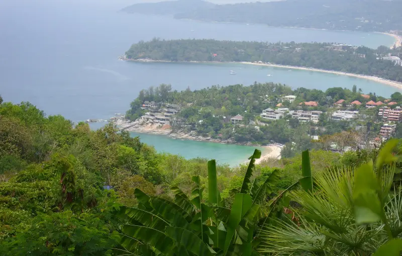
Karon Viewpoint (Thai จุดชมวิวสามหาด, “three beaches viewpoint”) is, in Karon municipality’s description, a landmark of the area, on a hill beside road 4233, which leads to Promthep Cape. A small pavilion stands at the top. From here you see three beaches: Kata Noi nearest, then Kata and Karon, curved like crescents and separated by rocks. You also see Ko Pu island and the mountains. On a clear day the water shades from light green near the shore to deep blue.
TAT Newsroom (2021) says the spot used to be called Kata Viewpoint and calls it a place for sunset photos. Karon municipality suggests stopping here before the sunset at Promthep.
Three viewpoints on one road
| Viewpoint | What you see | Distance reference |
|---|---|---|
| Karon Viewpoint | Kata Noi, Kata and Karon beaches, Ko Pu | 3.5 km from Kata, about 4 min |
| Black Rock (ผาหินดำ) | 360° view: Chalong Bay, Ko He and Ko Lone, Promthep Cape, Windmill Viewpoint, Nai Harn | 1.67 km from Karon Viewpoint per the municipality |
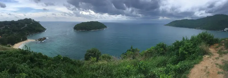
| Windmill | Ya Nui beach on one side, Nai Harn bay on the other | 6.1 km from Karon Viewpoint, about 8 min, 1.4 km from Promthep |
Karon municipality calls Black Rock a new spot for tourists. Its directions: from the Chalong five-way junction drive towards Rawai Beach, turn right towards Nai Harn, and after 800 m you reach a junction with a sign to the three beaches viewpoint; then follow the signs to “Laem Mum Nok”. Windmill, per TAT, is a few minutes’ drive from Promthep on the road to Nai Harn and is named after a large white windmill on the hill.
Opening hours and how to spend your time
Karon municipality and TAT give no hours or fee, so the regime is not confirmed as of 18 Oct 2026.
- A stop on the way. 15-30 minutes is enough at Karon Viewpoint, and about 1.5-2 hours for all three viewpoints with driving (Thaipedia estimate)
- Sunset. The municipality suggests stopping here before sunset at Promthep: it is 7.2 km and about 9 minutes from Karon Viewpoint to the cape
- Photos. TAT calls the spot good for sunset pictures
Sunset and season
Sunset time here matches Promthep to within a minute (Thaipedia estimate). Sunset is about 18:10 in October, about 18:04 in November and up to 18:48 in July, calculated with NOAA formulas; the full table is on the Promthep Cape page. A clear view is likelier in the dry months: by TMD normals December to March brings 24-82 mm of rain a month, while in September and October it rains on 22-23 days out of 30. More in Phuket weather by month.
| Period | What to expect |
|---|---|
| December-March | less rain, a cleaner view |
| April | hot, rains begin |
| May-October | rain, cloud can hide the view |
| November | fewer rains, sunset about 18:04 |
Getting there and how long it takes
We found no public transport to the viewpoint. People go by taxi, Grab, motorbike or their own car; see our guide to taxis in Phuket. On a motorbike remember the spot is on a hill.
| From | Distance | Time without traffic |
|---|---|---|
| Kata | 3.5 km | about 4 min |
| Patong | 15.5 km | about 18 min |
| Phuket Old Town | 17.8 km | about 21 min |
| Promthep Cape | 7.2 km | about 9 min |
OSRM calculation on OpenStreetMap data, route from Kata.
Fees
Karon municipality’s page gives no entry fee, and the official sources say nothing about a gate or ticket office. There is no DNP fee here: by DNP’s list Phuket has one national park, Sirinat in the north of the island (park status). If someone asks for money, ask who it is for and why.
What to do in the rain
In rain and low cloud the view from the top is hidden and the way up to the pavilion is wet. It is better to move the stop to a clear hour or to watch the sunset from a beach instead; for rainy days see our guide to Phuket in the low season.
Safety
- The road. The spot is on a hill: on a motorbike choose your speed and experience, especially in the rain
- The pavilion. In and just after rain the way up can be wet, and closed shoes are safer than flip-flops
- Sunset. It gets dark fast after sunset, so keep a phone torch for the way down
- Children. Keep them close at the edge of the viewing area
Children
It is a short stop with a pavilion and a view. The sources describe no railings, so keep children close and do not let them near the edge. More places for families are in our guide to Thailand with kids.
What to bring
- Water and a cap by day
- Closed shoes
- A phone with charge and a torch
- A light layer in case of wind
Who it suits and who it does not
- Suits: anyone heading to Promthep for sunset who wants to see the three beaches from above on the way, and anyone living in Kata
- Does not suit: anyone expecting a developed viewing area, anyone afraid of a mountain road on a motorbike, and anyone going in the rain
FAQ
Where is Karon Viewpoint and how do I get there from Kata?
It is on a hill beside road 4233, which leads to Promthep Cape, according to Karon municipality. From the centre of Kata it is 3.5 km and about 4 minutes by taxi, motorbike or car by OSRM, 15.5 km (18 minutes) from Patong and 17.8 km (21 minutes) from Old Town. We found no public transport timetable.
What can you see from Karon Viewpoint?
Karon municipality says you see a bay with three beaches: Kata Noi nearest, then Kata and Karon, curving like crescents with rocks between them. You also see Ko Pu island and the mountain ridge, and the water shades from light green near the shore to deep blue. A small pavilion stands at the top. TAT Newsroom adds that the spot used to be called Kata Viewpoint.
How much does Karon Viewpoint cost and when is it open?
Karon municipality's page gives no fee or hours, and TAT does not either. We found nothing on a gate or ticket office, so the regime is not confirmed as of 18 Oct 2026. Go by day or at sunset and ask on site if someone asks for money.
How is Karon Viewpoint different from Black Rock and Windmill?
Karon shows the three Kata and Karon beaches. Black Rock, per Karon municipality, gives a 360° view over Chalong Bay, Ko He and Ko Lone, Promthep Cape and Windmill Viewpoint, and is 1.67 km from Karon. Windmill (TAT) looks over Ya Nui and Nai Harn bay and is a few minutes from Promthep.
Is it better at sunset or in the daytime?
Karon municipality suggests stopping here before sunset at Promthep, and TAT calls the spot a place for sunset photos. Sunset is about 18:10 in October and up to 18:48 in July (Thaipedia calculation). By day the colours of the water are easier to see, but it is hotter.
Can I take children to Karon Viewpoint?
Yes, it is a short stop on a hill with a pavilion; the sources have no data on railings. Keep children close to you at the edge, and if you ride a motorbike with them, ride only if you are confident: it is a hill road.
What should I do if it rains?
In rain and low cloud the view is hidden, so move the stop. In September and October TMD normals show rain on 22-23 days out of 30, and from January to March on 3-8 days. Rainy-day ideas are in our low-season guide.
Sources
- Karon municipality. Three Beaches Viewpoint (Karon View Point), in Thai
- Karon municipality. Black Rock Viewpoint (ผาหินดำ), in Thai
- TAT Newsroom. Phuket and Phang Nga viewpoints are among the world's best for good reason (3 Mar 2021)
- Phuket Provincial Administration. Promthep Cape (Attractions: Cape)
- TMD. Climatological Data of Thailand for 30 Year Period (1991-2020), Phuket station
- OpenStreetMap. Karon View Point (node 1562239992), Black rock viewpoint (node 6265010759), Windmill Viewpoint (node 2513821648) and OSRM routes
Found an error or outdated fact? Tell the editors, we will fix it and update the check date.