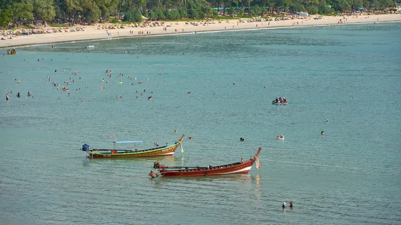

What kind of beach Kata is
Kata Beach sits on Phuket’s south-west coast in Karon subdistrict. It is a crescent bay with the small island of Koh Pu offshore, the beach’s landmark. The municipality gives no official length, and the outline in OpenStreetMap is tagged inconsistently, so we do not quote one.
What Karon Municipality says about Kata:
- it suits swimming and learning to dive, because a coral reef runs along the shore all the way to Koh Pu
- large casuarina and pandanus trees line the sand and give shade
- surfers come to Kata
- resort facilities are right there: hotels, tour desks, shops, entertainment
About 800 m south, at the end of the road, is Kata Noi: a short beach the municipality calls one of the most beautiful on Phuket. There are no nightclubs or bars, which is why the municipality recommends it for families. It also says Kata Noi is safe for swimming and the water is clear and calm almost all year. That is a tourist description, not a flag schedule: in the monsoon, still go by what the lifeguards allow.
Kata Beach weather by month
There is no weather station at the beach itself. Below are TMD normals for the Phuket town station and hotel occupancy for the whole province. Primary sources do not publish wave data by month, so we do not invent it: the monsoon is the guide.
| Month | Daytime, °C | Rain, mm | Rain days | Phuket hotel occupancy 2025, % | Monsoon |
|---|---|---|---|---|---|
| January | 33.0 | 49.9 | 5.6 | 86.4 | north-east, dry |
| February | 34.0 | 24.0 | 3.4 | 82.1 | north-east, dry |
| March | 34.4 | 80.7 | 7.5 | 79.4 | transition |
| April | 34.2 | 135.1 | 11.7 | 81.8 | transition |
| May | 33.2 | 236.9 | 18.9 | 74.0 | south-west |
| June | 32.6 | 249.4 | 18.6 | 66.8 | south-west |
| July | 32.3 | 240.2 | 19.1 | 70.7 | south-west |
| August | 32.2 | 308.7 | 19.5 | 68.9 | south-west |
| September | 31.8 | 350.4 | 21.7 | 65.8 | south-west |
| October | 31.8 | 336.0 | 22.7 | 77.6 | monsoon changeover |
| November | 32.1 | 178.2 | 15.9 | 78.6 | north-east |
| December | 32.1 | 82.0 | 10.3 | 84.1 | north-east |
Temperature and rain: TMD normals for 1991-2020, with a rain day counted from 0.1 mm. Monsoons as TMD describes them: north-east from October to February, south-west from May to October, with a transition in between. In 2026 TMD recorded the start of the rainy season on 15 May. Karon Municipality’s own profile gives April to November as the rainy season, wider than TMD’s.
How to read the table:
- December to March is the driest time, but hotels are also at their fullest: 86% in January 2025
- April is already hot, with up to 135 mm of rain, but the monsoon has not arrived yet
- May to October is the south-west monsoon, blowing off the Andaman Sea straight onto the west-coast beaches. Rawai Municipality says neighbouring Nai Harn has strong waves in these months and swimming is not advised. We found no official flag or lifeguard schedule for Kata, so swim only where lifeguards allow it. For what the flags mean and how to handle a rip current, see red flags and rip currents in Phuket, and for calmer spots in these months, calm beaches in Phuket.
- November is a transition month, with half October’s rain
The full climate table with humidity and night-time lows is on Phuket weather by month. Travelling between May and October? Read Phuket in the low season.
Who Kata suits
- Dry-season holidays with swimming and snorkelling: the reef runs from the shore to Koh Pu
- People who want to stay by the beach with hotels, cafes and tour desks nearby
- Families with children: neighbouring Kata Noi, with no bars or clubs, is the easier choice
It does not suit anyone hoping for an empty beach in high season, or people who fly often: the airport is almost an hour away.
Getting there
| From | km | Minutes without traffic |
|---|---|---|
| Phuket Airport (HKT) | 46.1 | 52 |
| Phuket Old Town | 15.9 | 20 |
OSRM routing on OpenStreetMap data, 17 October 2026. Karon Municipality gives about 17 km from Kata to town, close to our figure; the difference is the starting point.
Where to stay nearby
Kata belongs to Karon subdistrict. Karon Municipality, which runs the subdistrict, has 7,626 registered residents (DOPA, December 2025). Neighbouring Rawai has 19,659.
Condos. The Treasury Department register lists 29 residential condominiums in Karon subdistrict with issued unit titles. Their median valuation is THB 59,000 per m², second only to Kamala (THB 59,250) among Phuket subdistricts with 10 or more buildings in the register (island-wide median: THB 48,250). This is a government valuation for taxes and fees, not a sale price.
New projects. In the Smart EIA Plus database, these condominiums with “Kata” in their name have passed environmental review since 2021:
| Project (as named in the EIA register) | EIA approval date |
|---|---|
| Kata View Condo | 17 March 2023 |
| V Kata 3 (วี กะตะ 3) | 21 June 2023 |
Two more are under review: The Vintage Kata and Kata-Skye. We searched by name, so projects without “Kata” in the name are not included. EIA approval says nothing about tenure or completion dates: both are to be confirmed from each project’s documents.
If you are thinking of staying longer than a holiday, start with the Kata area guide for living there.
FAQ
Can you swim at Kata Beach in the rainy season?
Phuket's rainy season runs from May to October, driven by the south-west monsoon off the Andaman Sea, and Kata faces straight into it. For nearby Nai Harn, Rawai Municipality says waves are strong in those months and swimming is not advised. We found no official flag or lifeguard schedule for Kata, so from May to October swim only where and when the lifeguards on duty allow it.
Kata or Kata Noi: which is better?
Kata is bigger, lined with hotels, tour desks, shops and entertainment. Kata Noi is 800 m south at the end of the road, a short beach that Karon Municipality describes as quiet, with no nightclubs or bars, and good for families. Pick Kata Noi for peace and children, Kata for facilities.
Is there snorkelling at Kata Beach?
Karon Municipality says a coral reef runs along Kata's shore all the way to Koh Pu, which is why the beach suits swimming with a mask and learning to dive. Head out to the reef in the dry season, December to March, outside the south-west monsoon.
How far is Kata Beach from Phuket Airport?
46.1 km by road, about 52 minutes without traffic, according to OSRM routing on OpenStreetMap data. The airport is in the north of the island and Kata in the south-west, so the drive crosses the whole island and takes longer at rush hour.
What is the weather like at Kata in October?
October is one of Phuket's two wettest months: on average 336 mm of rain and 22.7 rain days, according to Thai Meteorological Department normals for 1991-2020. Daytime highs are around 32 °C. Phuket hotel occupancy in October 2025 was 77.6%, lower than in December and January.
Where is Kata Beach on the map?
On Phuket's south-west coast, between Karon Beach to the north and Kata Noi to the south, in Karon subdistrict of Mueang Phuket district. OpenStreetMap puts the middle of the beach at 7.8194, 98.2981. Koh Pu island sits just offshore.
Sources
- Karon Municipality. Kata Beach (Thai)
- Karon Municipality. Kata Noi Beach (Thai)
- Karon Municipality. General information (Thai)
- Rawai Municipality. Nai Harn Beach, waves May-October (Thai)
- Thai Meteorological Department. Climatological Data of Thailand for 30 Year Period (1991-2020)
- Thai Meteorological Department. Monthly Climate Summary, May 2026
- Ministry of Tourism and Sports. Provincial statistics by month, 2025 (2568R)
- OpenStreetMap, OSRM route: HKT airport to Kata
- OpenStreetMap, OSRM route: Kata to Phuket Old Town
- Treasury Department. Condominium appraisal values (condo_all, snapshot 2024-08-05)
- ONEP. Smart EIA Plus database
- DOPA, Ministry of Interior. Registered population by subdistrict, December 2025
Found an error or outdated fact? Tell the editors, we will fix it and update the check date.