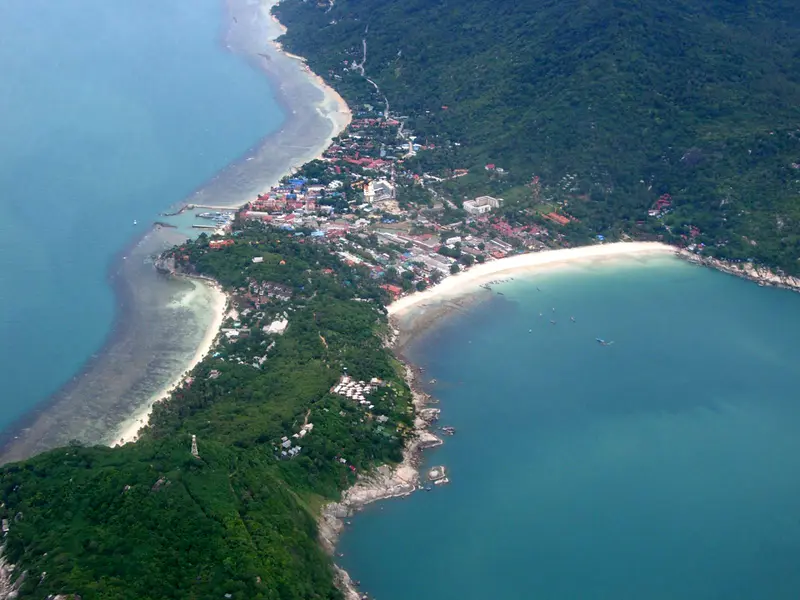

Where Haad Rin is
Haad Rin (also spelled Hat Rin) is a village on the south-eastern peninsula of Koh Phangan, in Ban Tai subdistrict. It sits on an isthmus: Haad Rin Nok beach on the east side, Haad Rin Nai on the west, with streets of shops, cafes and accommodation in between. At the southern edge is the Haad Rin Queen pier, with boats to Samui.
Ban Tai subdistrict had 5,257 registered residents in December 2025. DOPA does not publish a figure for the village.
Who Haad Rin suits
- People coming for the parties. Haad Rin is known for full moon parties on Haad Rin Nok beach; the organisers announce the dates
- People who want two beaches close together. The east and west beaches are separated only by the narrow isthmus and can both be walked in an evening
- People arriving straight from Samui. Haadrin Queen boats dock at the pier in the village, no drive across the island needed
- Short stays. OpenStreetMap shows 25 convenience stores within a kilometre, but no supermarket
Who Haad Rin does not suit
- Anyone looking for quiet. On party nights the village and the beach are packed
- Families staying long-term. There are no international schools in the village; both OPEC-licensed schools are elsewhere in Ban Tai subdistrict, and the village has a state school with 99 pupils
- Anyone who wants a hospital close. The state Ko Pha Ngan Hospital is 13.8 km and 22 minutes away, private Phangan International 8.1 km
- Condo buyers. The Treasury registry lists no condominiums on Phangan
Haad Rin in numbers
| Indicator | Value | Source, date |
|---|---|---|
| Residents of Ban Tai subdistrict | 5,257 | DOPA, December 2025 |
| Condos on the Treasury registry | 0 | Treasury, snapshot of 05.08.2024 |
| To Thong Sala pier | 11.0 km, 17 min | OSRM, 17.10.2026 |
| To the state hospital | 13.8 km, 22 min | OSRM, 17.10.2026 |
| Convenience stores within 1 km | 25, no supermarket | OpenStreetMap, 17.10.2026 |
| Annual rainfall | 1,994 mm | TMD, 1991-2020 normals, Ko Samui station |
The seasons are those of the whole island: dry in February and April, wettest from October to December (445 mm in November). Month by month in the Koh Phangan hub.
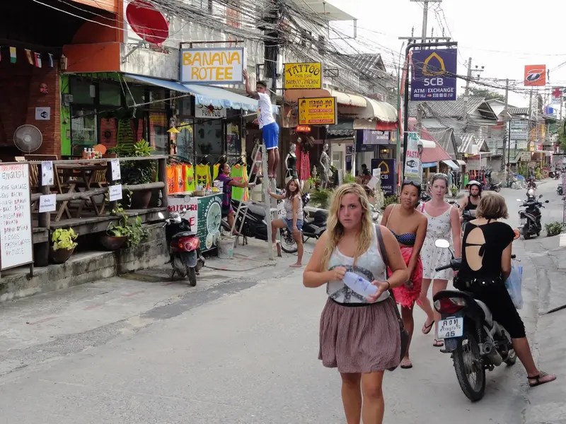
Beaches and places
| Place | What it is |
|---|---|
| Haad Rin Nok | east beach, venue of the full moon parties |
| Haad Rin Nai | west beach on the other side of the isthmus, quieter |
| Haad Rin Queen pier | boats to Samui |
| Ban Tai beach | 6.7 km by road, the calm south coast, see Ban Tai |
Housing in Haad Rin
The Treasury registry lists no condominiums on Phangan (snapshot of 05.08.2024). Housing in Haad Rin means guesthouses, bungalows and villas on the slopes of the peninsula. Foreigners cannot own land in their own name; a 30-year lease is the usual route, see freehold and leasehold. We do not publish rents until we have our own dated measurements.
Living in Haad Rin: schools, hospitals, shops, transport
Schools. Ban Haad Rin state school, Moo 6 of Ban Tai subdistrict, kindergarten to grade 6, 99 pupils (OBEC, 2020). The international schools Siripanya and Phangan International are registered in Moo 1 of Ban Tai subdistrict, closer to Thong Sala.
Hospitals. Phangan International (private, 9 beds) is 8.1 km and 13 minutes away; the state Ko Pha Ngan Hospital 13.8 km and 22 minutes. Beds from the HSS list of 31.07.2026, OSRM distances on 17.10.2026.
Shops. OpenStreetMap shows 25 convenience stores within a kilometre; for Lotus’s, Big C and Tops people drive to Thong Sala.
Transport. Haadrin Queen boats to Samui leave from the village pier. We found no official routes with timetables on the island: taxi, scooter, car.
Haad Rin compared
| Area | Subdistrict | From Haad Rin | To the state hospital | Supermarkets nearby |
|---|---|---|---|---|
| Haad Rin | Ban Tai | 0 | 13.8 km | none |
| Ban Tai | Ban Tai | 6.7 km, 11 min | 7.5 km | none, in Thong Sala |
| Thong Sala | Ko Pha Ngan | 11.0 km, 17 min | 4.0 km | Lotus’s, Big C, Tops |
| Srithanu | Ko Pha Ngan | about 18 km | 4.5 km | 1 |
Sources: OSRM routes on OpenStreetMap (17.10.2026), shops from OpenStreetMap (17.10.2026). The Srithanu distance is the sum of the routes via Thong Sala.
Homes in Haad Rin
Haad Rin and nearby areas
Computed from our project registry and catalogue at build time.
| Area | Projects | L1 | Under construction | Completed | On sale |
|---|---|---|---|---|---|
| Haad Rin | 0 | 0 | 0 | 0 | 0 |
| Ban Tai | 0 | 0 | 0 | 0 | 0 |
| Thong Sala | 0 | 0 | 0 | 0 | 0 |
| Srithanu | 0 | 0 | 0 | 0 | 2, from ฿7.8M |
FAQ
Where is Haad Rin?
At the south-eastern tip of Koh Phangan, in Ban Tai subdistrict. The village sits on an isthmus between two beaches: Haad Rin Nok faces east, Haad Rin Nai faces west. Thong Sala pier is 11 km away along the south coast road.
When is the Full Moon Party?
The parties follow the full moon, but the organisers announce each date. We found no official calendar on government websites, so we do not publish dates: check with the organisers closer to your trip.
How do I get to Haad Rin from Samui?
Directly on a Haadrin Queen boat to Haad Rin pier, or on a Lomprayah boat to Thong Sala (20-30 minutes, 250-350 baht on the 2026 timetable) and then 11 km by road. On party nights check the boat schedule with the operator in advance.
Can you live in Haad Rin long-term?
You can, but there are clear drawbacks: the state hospital is 13.8 km away, the Thong Sala supermarkets 11 km, and the only school in the village is a state primary school with 99 pupils. Most long-stayers on the island choose Ban Tai, Thong Sala or Srithanu.
Is there a hospital in Haad Rin?
There is no hospital in the village. The nearest private one, Phangan International (9 beds), is 8.1 km and about 13 minutes away; the state Ko Pha Ngan Hospital is 13.8 km. Serious cases go to Samui.
Where can you swim in Haad Rin?
On both beaches of the peninsula. Haad Rin Nok is long and faces east, and on party nights it is packed; Haad Rin Nai on the west side is quieter. Further north-east along the coast are more secluded bays, reached by hill road or by boat.
Sources
- DOPA, Ministry of Interior. Population by subdistrict, December 2025
- OBEC. State school list (obec-school-007, 2020 academic year)
- OPEC. Ministry of Education private school register
- Ministry of Public Health, HSS. Licensed private hospitals as of 31.07.2026 (PDF)
- Haadrin Queen. Phangan-Samui boat
- Lomprayah. 2026 timetable
- Thai Treasury. Condominium valuations (condo_all, snapshot of 05.08.2024)
- TMD. Climatological Data of Thailand for 30 Year Period (1991-2020), Ko Samui station
- OpenStreetMap. Haad Rin Nok (way 244555510), Haad Rin Nai (way 244555505), Haad Rin Queen pier (way 484301885)
- OpenStreetMap, Overpass API: shops, data as of 17.10.2026
- OpenStreetMap, OSRM route: Haad Rin to Ko Pha Ngan Hospital
- OpenStreetMap, OSRM route: Haad Rin to Phangan International Hospital
- OpenStreetMap, OSRM route: Ban Tai beach to Haad Rin
Found an error or outdated fact? Tell the editors, we will fix it and update the check date.